JWST Position Angles, Ranges, and Offsets
Users should be familiar with JWST position angles, coordinate systems, and related nomenclature to understand the telescope’s pointing constraints.
On this page
Observations that need specific orientations for a particular instrument's field of view on the sky can run into complications due to constraints on where JWST can point relative to the sun. There are APT special requirement parameters available for specifying pointing restrictions, if needed.
Reference angle definitions
See also: JWST Observatory Coordinate System and Field of Regard, JWST Field of View, JWST Instrument Ideal Coordinate Systems
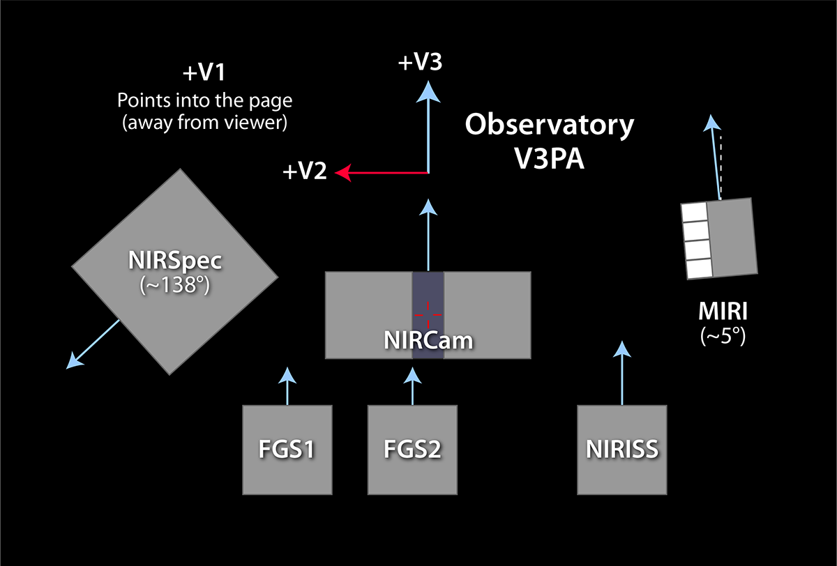
The observatory coordinate system (V1, V2, V3) is used in operations (Figure 1). The V3 axis is the relevant vector for science planning. V3 PA is the position angle (PA) of the V3 reference axis eastward relative to north when projected onto the sky.
Official reference positions and angles relative to V3 PA for all defined apertures (or FOVs) are maintained in the Science Instrument Aperture File (SIAF). The SIAF is a controlled document referenced by all relevant software in the JWST operations area. It contains detailed definitions of every instrument, defined aperture, subarray, detector, and even information about transformations and distortion corrections.
A desired orientation or range of orientations for an instrument field of view (FOV) can be specified in the Astronomer Proposal Tool's (APT) special requirements. For a selected instrument (or mode, or a subarray), this orientation is expressed as the aperture position angle (APA), that is, the position angle for the "science y-axis" of the specific instrument FOV or detector being referenced (measured eastward from north).
Table 1 provides information on the offset from instrument y-axis to V3 PA for each science instrument. Some instruments are closely aligned to the V3 axis. Therefore, in most cases, planning tools for those instrument modes will report little difference between V3 PA and APA values. Also, because the V3 axis is defined relative to the bore sight and the instrument fields are offset from that, there can be additional small variations between the APA and V3 PA angles, especially if the target position is very close to one of the celestial poles.
Most observers are likely to be focused on the APA for their instrument of choice. That is, what is the angle on my selected instrument FOV on the sky? However, since APT needs to accommodate all instruments and also is the interface into the scheduling system downstream, it works in the observatory coordinate system, and converts angles to APA as needed. Users should be aware of these different coordinate systems and how they are used APT and other planning tools. For example, diagnostics reported by the APT Visit Planner report angles in V3 PA, and the Aladin display element in APT is also referenced to V3 PA, since these tools apply to all instruments. In most places in the APT GUI where angles are shown, both APA and V3 PA are shown for reference. The JWST target visibility tools provide information about both V3 PA and APA (and the offsets between them, if any) for the various instruments.
Table 1. Offset angle relative to Observatory V3 axis for science instruments
| Instrument | Offset angle from V3 |
|---|---|
| NIRCam | 0.0° |
| MIRI | 4.84° |
| NIRISS | 0.57° |
| NIRSpec | 138.5° |
These are reference values only: Particular apertures within an instrument can vary greatly (for example, the MIRI MRS and 4QPM coronagraph).
Figure 1 shows these reference axes in the context of the JWST focal plane. Note that the two Fine Guidance Sensors are also closely aligned with NIRCam and with V3.
APT special requirements controlling position angle
See also: Aperture Position Angle Special Requirements, APT Visit Planner, JWST Target Visibility Tools
See also: Using Aladin and APT Visit Planner
Words in bold are GUI menus/
panels or data software packages;
bold italics are buttons in GUI
tools or package parameters.
These position angle special requirements are specified as follows:
Aperture PA [value1] to [value2] Degrees [followed by V3 PA information]
- a minimum and maximum value are requested by the GUI in APT. (They can be the same, but this imposes strict scheduling constraints.)
- An example GUI display would look like Aperture PA Range 135 to 145 Degrees (V3 130.16455103 to 140.16455103)
APERTURE PA OFFSET [obs#] FROM [obs#] BY [XX] Degrees TO [YY] Degrees
- a minimum and maximum value are requested by the GUI in APT. (They can be the same, but this imposes strict scheduling constraints.)
- An example GUI display: Aperture PA offset 1 FROM 2 BY 10 Degrees TO 15 Degrees (Same offsets in V3)
SAME APERTURE PA [obs#] , [obs#]
- An example GUI display: SAME APERTURE PA 2, 3
The APT Visit Planner contains diagnostic plots to assess the allowed angles versus time and will flag unschedulable requests at the times they are specified. However, users with PA constraints or those who desire offsets may find it advantageous to use one of the target visibility tools prior to entering observations into APT to understand the overall schedulability and PA flexibility for a given target. Indeed, some pre-planning may save significant time and possibly wasted effort downstream in APT in the event that certain desired angles or offsets are not available due to observatory level constraints
Use of position angle special requirements can force observations to be scheduled in the portion of their visibility that is within the micrometeoroid avoidance zone. Observations in this region are not forbidden, but should only be requested if scientifically justifiable. APT warns users when this is being requested and asks if mitigation is possible.
The effect of a target's ecliptic latitude
See also: JWST Target Viewing Constraints, JWST Orbit
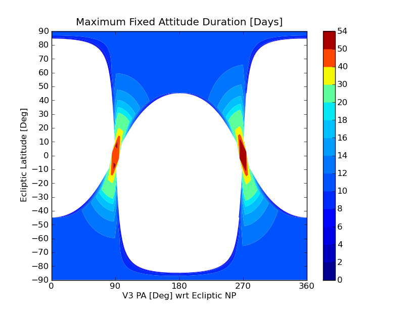
Astronomical targets near the ecliptic plane are observable by JWST over restricted time periods; even when they're available, the ranges of position angles for the JWST field of view on the sky will be nearly fixed (although still allowing the nominal roll flexibility of roughly ±5°).
Targets near the ecliptic poles can be observed at nearly any time, and at any PA on the sky at some time during the calendar year. But again, at any given time, a high ecliptic latitude target will have a nominal PA with only about ±5° flexibility. This limits the length of time a target in this region can be observed at the same PA (for instance, a large mosaic observation).
At and below roughly 45° in ecliptic latitude, the available observing windows and PAs on the sky become more severely restricted, but the length of time one can remain at a given valid PA increases. Figure 2 demonstrates these restrictions graphically.
Why do these restrictions occur?
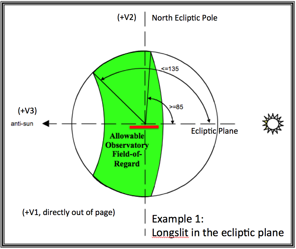
Two extreme cases are illustrated below.
First, consider a target located in the ecliptic plane (see Figure 3). Such a target will be visible to JWST instruments for two ~50 day periods, approximately 6 months apart, as the target cuts through the projected annular JWST field of regard (FOR) on the sky. Then, consider an imaginary long slit along the [V3] axis, as shown by the red bar in Figure 3; it is essentially oriented along the ecliptic plane at all times while the target is visible to the observatory. The PA of the JWST FOV on the sky will only have an instantaneous roll flexibility of about ±5° during this time. A large range of PAs will never be available to JWST for targets at low ecliptic latitudes. This limitation only improves slowly with increasing (absolute) ecliptic latitude until ecliptic latitudes of about 40°–45° are reached (see Figure 2).
Examples
The schedulability of requested observations can be very limited when specifying PAs and offsets, especially if fixed angles or small ranges of allowed angles are involved. Hence, these special requirements should only be used when truly necessary for the science. However, there are a number of expected situations that will require this capability.
Coronagraphy
See also: JWST High-Contrast Imaging Roadmap, JWST Coronagraphic Visibility Tool Help
One of the most significant applications of constrained PAs and angle offset specifications will be coronagraphic observations with MIRI and NIRCam. For example, PA changes between separate coronagraphic integrations will help to identify real structure in and around a target from substructure within the point spread function (PSF). Because of concerns about changes in the PSF with time (due to thermal changes or drifts in the mirror alignments), many users will want to roll dither on coronagraphic targets at the time of their observations. Practically speaking, this will usually mean 2 back-to-back observations made at ±5° from nominal observatory roll at the time of the observations (for example, a first integration at −5° from nominal roll followed by one at +5°—note that no observation is taken at nominal roll).
Certain cases may also need follow up at some more substantial angular offset (e.g., 30° offset) relative to the first observations, which will need to be scheduled at a significantly later time. (Note also the potential impacts of targets at low ecliptic latitudes, for which this may be impossible due to the observatory roll restrictions.) Coronagraphic observers will want to assess their potential targets carefully, and when possible, select targets above 45° ecliptic latitude if they require large offsets in PA between observations. To help assess these situations quickly and easily, a coronagraphic target visibility tool is available to users.
Near and mid-IR imaging and mosaics
Some programs will want to obtain near- and mid-IR imaging, using NIRCam and MIRI, of a similar region on the celestial sphere. The use cases vary from a single field to larger mosaicked fields to covering an entire region such as the HUDF, or an extended source such as a nearby galaxy or H II region. Because the field sizes (and orientations at some level) are different between the cameras, some users will not only want to orient one of the cameras in a certain way to cover a desired region, but may also want to align (or roughly align) the 2 camera fields of view as projected onto the sky in order to maximize the overlap.
To visualize this, imagine that a single NIRCam field is obtained on an extended object, and a user wants to cover the same region with MIRI. A MIRI mosaic will be required because the MIRI field of view is smaller. If the MIRI observation is scheduled with the field rotated by 45° from the NIRCam observations, the corners of the MIRI fields in the mosaic will hang outside of the NIRCam region, and it will likely require more MIRI pointings to cover the region of interest. A user would likely want specify a PA constraint on the MIRI observation to align (at least approximately) the MIRI field of view with that of the NIRCam observation. (Note, however, there may be allowable options offset by 90° or 180° that would increase schedulability, at least for targets above absolute ecliptic latitude, |~45°|.)
Complications
There are subtleties that can arise in the JWST planning system due to the offset between the origin of the observatory coordinate system and the coordinate system based on a given instrument aperture. Considerable effort has been expended to insulate the science user from this underlying complexity, but it may still be of use to understand that it exists.
As mentioned above, the JWST planning and scheduling system itself will operate on a system of axes (V1, V2, V3) defined with respect to the observatory. Hence, while science users may specify a PA of a particular instrument/aperture on the sky for a given observation, or a relative orientation rotated around the target location, the observatory is actually referenced to (and rotated about) the V1 axis (the boresight), which is not coincident with the target. For most cases, the difference in angles is slight and inconsequential. However, in a worst case scenario, close to the celestial poles, a target and the V1 axis position could be at significantly different angles with respect to the pole, which is a complication that the planning system handles internally.
Another subtlety involves the ±5° guideline on the nominal roll flexibility. The ±5° is not a hard number, but rather varies from ±3° (at 85° sun angle) to ±7° (at 135° Sun angle). Thus, with careful planning, operations may be able to squeeze out an extra degree or two of roll flexibility, but it will come at the cost of making a given observation more restricted in terms of when it can be scheduled. There may be special applications, for instance, in certain coronagraphy programs, where this extra angular offset will benefit the science. Fixing observations toward the large end of this range will be very restrictive to scheduling and should only be done when scientifically justified.


